
The global haulage industry is currently grappling with a staggering 30% empty-running rate, a figure that represents billions in lost revenue and millions of tons of unnecessary carbon emissions. For years, the sector operated on the edge of “good enough,” but the convergence of soaring fuel costs and a plummeting profit margin—now hovering around a razor-thin 1.5%—has made inefficiency an existential threat. Precision logistical mapping has emerged as the definitive technological intervention, promising to bridge the gap between abstract planning and the gritty reality of the open road.
This technology represents a fundamental departure from the consumer-grade navigation systems that have long plagued commercial fleets. While standard GPS focuses on the shortest distance between two points, precision logistical mapping prioritizes the “smartest path,” a calculation that balances time, fuel consumption, and vehicle-specific limitations. By integrating high-fidelity geospatial intelligence with commercial constraints, this framework aims to resolve the “efficiency debt” that has accumulated through decades of fragmented operational habits.
Introduction to Precision Mapping in Logistics
Precision logistical mapping is a specialized technological framework designed to optimize the movement of goods through high-fidelity data and HGV-specific routing logic. Unlike standard consumer navigation, this technology integrates core principles of geospatial intelligence, real-time telemetry, and commercial vehicle constraints to create a high-performance operational environment. It has emerged as a critical response to the shrinking profit margins and systemic inefficiencies within the global supply chain, evolving from simple GPS tracking into a sophisticated strategic asset.
The primary objective of these systems is to eliminate the guesswork that often leads to “out-of-route” mileage. In a commercial context, a single wrong turn or an unplanned detour due to a low-hanging bridge can cost hundreds of dollars in fuel and labor. By providing a granular view of the road network, precision mapping transforms navigation from a passive guidance tool into a proactive management system. This shift allows hauliers to regain control over their operational costs, ensuring that every mile driven contributes directly to the bottom line rather than being swallowed by avoidable waste.
Architectural Components and Strategic Features
Commercial-Grade Routing and HGV Constraints
At the heart of precision mapping is the shift from “shortest path” to “smartest path” logic. This component accounts for physical and legal variables such as bridge heights, weight limits, axle restrictions, and low-emission zones. By tailoring navigation to the specific dimensions of Heavy Goods Vehicles (HGVs), the technology ensures safety and compliance while reducing out-of-route mileage. This is not merely a safety feature; it is an economic driver that prevents the expensive delays associated with getting a forty-ton truck stuck in an urban environment ill-equipped for its size.
Furthermore, these routing algorithms are increasingly incorporating dynamic environmental data. For example, the software can suggest alternative paths based on real-time wind speed or road elevation, factors that significantly impact the fuel efficiency of a fully loaded trailer. This level of detail allows planners to select routes that minimize the mechanical strain on the vehicle, extending the lifespan of the fleet while keeping fuel expenditure at a minimum.
Integrated Back-Office and In-Cab Synchronization
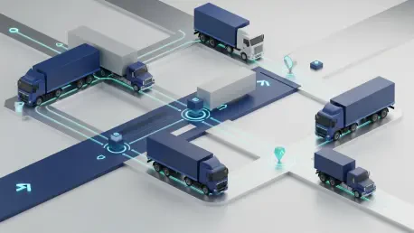
This feature addresses the historical disconnect between central dispatch and the driver. By utilizing cloud-based platforms, the technology creates a “single source of truth” where planners and drivers operate on identical data sets. This real-time synchronization allows for proactive adjustments to routes and schedules, ensuring that central efficiency goals are executed accurately on the road. When a dispatcher updates a delivery window or adds a backhaul opportunity, the driver’s navigation updates instantly, removing the friction of manual communication.
This synchronization also serves as a performance audit tool. By comparing the planned route against the actual path taken, companies can identify patterns of deviation and address the root causes, whether they be driver behavior or outdated map data. This feedback loop ensures that the operational strategy is constantly refined, moving away from static plans toward a dynamic, living workflow that responds to the realities of the road as they happen.
Emerging Trends and Technological Innovations
The field is currently seeing a rapid shift toward automated market intelligence and dynamic data integration. New innovations focus on “predictive mapping,” where historical traffic patterns and weather data are used to anticipate delays before they occur. Additionally, there is an increasing trend toward “freight-matching” integration, where mapping software identifies nearby spot-market opportunities to minimize empty running. These developments are driven by an industry-wide push to eliminate the 30% of empty kilometers that currently drain haulage profitability.
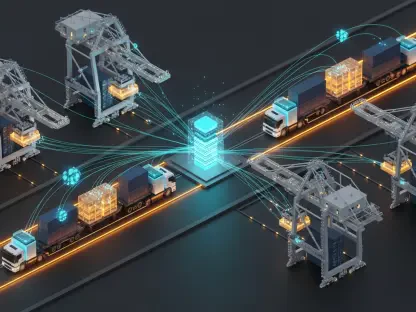
We are also witnessing the rise of decentralized data sharing between fleets. By pooling anonymized data on road conditions and wait times at loading docks, precision mapping platforms are creating a more comprehensive picture of the logistical landscape than any single carrier could achieve alone. This collective intelligence allows even small hauliers to benefit from big-data insights, leveling the playing field and driving industry-wide standards for efficiency and reliability.
Real-World Applications and Sector Deployment
Heavy Haulage and Long-Haul Logistics
The most prominent application is in long-haul trucking, where even a 1% improvement in route efficiency results in massive fuel savings. Companies are deploying these systems to manage complex international corridors, navigating varying regional regulations with automated precision. In these scenarios, the mapping software acts as a regulatory compliance engine, automatically adjusting routes to avoid tolls or restricted zones that vary from one jurisdiction to the next, thereby avoiding heavy fines.
Moreover, in the sector of specialized heavy haulage—such as the transport of wind turbine blades or industrial machinery—precision mapping is indispensable. These loads require “envelope-based” routing where every inch of clearance is measured. The ability to simulate a route in a 3D digital twin environment before the vehicle ever leaves the yard reduces the risk of catastrophic infrastructure damage and ensures that these high-value projects remain on schedule.
Driver Training and Workforce Retention
A unique use case for precision mapping is its role as a recruitment tool. By providing 3D maps, safety-focused views, and intuitive voice instructions, the technology lowers the barrier to entry for inexperienced drivers. This deployment helps mitigate the global driver shortage by reducing the stress associated with navigating unfamiliar or restricted urban environments. In a profession where turnover is notoriously high, providing tools that make the job less taxing is a significant competitive advantage.
The psychological impact of reliable technology should not be understated. When a driver trusts their navigation system, they can focus more on safe driving and less on the anxiety of potential route violations. This leads to a more satisfied workforce and a reduction in minor accidents caused by driver distraction. By lowering the cognitive load on the operator, precision mapping creates a safer, more professional environment that appeals to a younger, more tech-savvy generation of drivers.
Operational Challenges and Implementation Barriers
Despite its benefits, the technology faces hurdles regarding data fragmentation and initial capital investment. Integrating legacy fleet management systems with new precision mapping software can be technically demanding, often requiring significant custom API development. Furthermore, regulatory shifts in different territories require constant updates to map layers to remain compliant. For smaller carriers with limited IT budgets, the “barrier to entry” remains high, creating a digital divide between large-scale logistics giants and independent operators.
Another challenge lies in the quality of the data itself. While urban areas are often mapped with high precision, rural or industrial zones may lack the granular detail required for heavy vehicle navigation. This can lead to a “last mile” problem where the software provides excellent guidance on highways but fails as the vehicle nears a remote delivery site. Ongoing development efforts are focused on creating more “plug-and-play” solutions and utilizing crowd-sourced data to fill these geographical gaps.
Future Trajectory and Industry Impact
Precision logistical mapping is heading toward a future defined by autonomous coordination. We can expect breakthroughs in AI-driven load optimization, where vehicles autonomously “negotiate” backhaul opportunities based on their mapped trajectory. Long-term, this technology will likely become the foundational layer for autonomous trucking fleets, where the precision of the map is not just a guide but a critical safety requirement for driverless operations. The map will transition from a visual aid to a high-definition sensor input for the vehicle’s computer.
As we look toward the next several years, the integration of 5G and satellite-based IoT will allow for “living maps” that update in milliseconds. Imagine a scenario where a road closure is reflected on every truck’s navigation system within seconds of the incident occurring, with rerouting handled automatically by a central AI coordinator. This level of synchronization will push the industry closer to the goal of “zero-waste” logistics, where empty miles are a relic of the past and the entire supply chain moves with the precision of a clockwork mechanism.
Final Assessment of Precision Logistical Mapping
Precision logistical mapping transitioned from a niche luxury to a survival necessity for the haulage industry. By addressing the “efficiency debt” and reducing the prevalence of empty miles, it provided a robust solution to the sector’s recent economic crisis. While challenges in integration remained, the potential for increased profitability and enhanced driver safety made it a cornerstone of modern logistics. The technology effectively turned operational waste into sustainable revenue, proving that in a volatile market, data is as valuable as fuel.
To move forward, hauliers must prioritize the adoption of unified data standards to ensure different platforms can communicate seamlessly. The next logical step involves expanding these systems into “ecosystem mapping,” where warehouses, ports, and carriers share a synchronized digital interface to eliminate waiting times. By investing in these collaborative tools, the industry can finally move beyond individual optimization toward a holistic, high-velocity supply chain. The verdict was clear: those who embraced the precision of the map didn’t just find their way; they secured their future.