
Modern computing has reached a definitive tipping point where the boundary between binary data and our physical surroundings is no longer just blurred but effectively dissolved by persistent world models. Spatial intelligence platforms represent the culmination of this evolution, moving beyond static mapping into a realm where machines possess a nuanced awareness of their environment. This shift is driven by the necessity for systems that do not merely record pixels but interpret the three-dimensional geometry and logistical context of a space. By integrating consumer-grade accessibility with high-end industrial precision, these platforms have redefined how we interact with the “digital twin” of our reality.
Understanding the Rise of Spatial Intelligence Systems
The emergence of spatial intelligence stems from a fundamental dissatisfaction with traditional geospatial data, which often lacks the granularity required for autonomous interaction. While earlier systems relied on satellite imagery or basic LiDAR, current platforms utilize a convergence of 3D reconstruction and computer vision to build “world models” that are both live and collaborative. This technological leap allows for a bidirectional flow of information where the physical world informs the digital model, which in turn guides physical actions with incredible accuracy.
This advancement is unique because it leverages the ubiquity of standard consumer hardware to accomplish what previously required multi-million-dollar survey equipment. By turning every smartphone into a sophisticated spatial sensor, the industry has effectively decentralized data collection. This democratization means that spatial intelligence is no longer a localized research project but a foundational layer for the global technological infrastructure, influencing everything from urban planning to personal navigation.
Core Pillars: Reconstruction and Localization
3D Capture and Reconstruction via Scaniverse
Scaniverse has established itself as a critical gateway for spatial data acquisition by simplifying the complex mathematics of photogrammetry into a mobile-first experience. Users can generate high-fidelity spatial assets, such as Gaussian splats and textured meshes, using nothing more than a standard smartphone or a 360-degree camera. This capability matters because it removes the high barrier to entry for small-scale developers and industrial teams who need to digitize environments ranging from tiny mechanical rooms to massive factory floors.
Unlike competitors that often require cloud-tethered processing for even the simplest tasks, this platform emphasizes a hybrid approach that balances local capture with web-based management. This implementation is particularly effective for professional workflows where data must be shared and refined across global teams. The result is a system that treats the physical world as a malleable asset, allowing users to “copy and paste” reality into digital simulations with professional-grade geometric integrity.
High-Precision Orientation with VPS 2.0
While capturing a space is one challenge, navigating it requires the Visual Positioning System (VPS) 2.0, which provides a transformative alternative to traditional satellite-based location services. GPS frequently fails in “urban canyons” or beneath concrete structures, often yielding errors of several meters. In contrast, VPS 2.0 utilizes 6DoF (six degrees of freedom) localization to achieve centimeter-level precision. This is not just a marginal improvement; it is a shift from knowing which street a device is on to knowing exactly which shelf or valve a robot is facing.
The most distinctive feature of this system is its ability to operate without the prerequisite of a prior, exhaustive scan of every new environment. By utilizing real-time visual cues to orient the user against known spatial anchors, it facilitates navigation in GPS-denied zones like underground tunnels or intricate interior warehouses. This level of reliability is what makes autonomous operations viable in the real world, as it provides the constant, drift-free positioning required for safe and efficient movement.
Emerging Trends in World Modeling
Current industry trajectories suggest a transition from purely geometric models to those defined by semantic intelligence. Instead of seeing a collection of points in space, these systems are beginning to identify objects by their function and relationship to one another. Innovations such as persistent, shared digital twins allow multiple users to interact with the same spatial data simultaneously, ensuring that the digital model evolves in real-time as the physical environment changes.
Moreover, the integration of cloud-based collaborative workflows has changed how spatial data is managed. Rather than hoarding data in silos, modern platforms encourage a “living map” philosophy where every capture contributes to a larger, more accurate representation of the environment. This shift toward collaborative spatial awareness is a key differentiator, as it allows for a collective intelligence that benefits all users of the platform, regardless of their individual hardware capabilities.
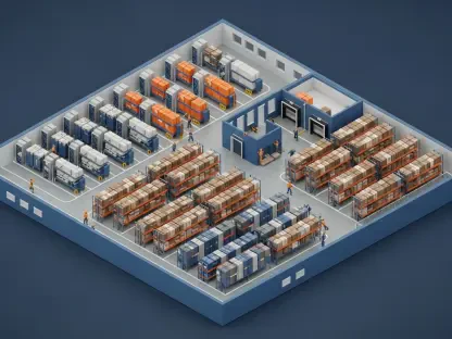
Real-World Applications Across Industrial Sectors
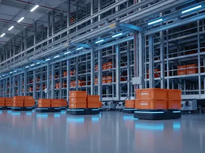
In the robotics sector, the implementation of VPS 2.0 has solved the “handoff” problem, where autonomous units previously lost their way when moving from outdoor GPS signals to indoor visual environments. Now, these units maintain a continuous, high-fidelity sense of position, which is vital for logistics chains that span multiple environments. This seamless transition is something traditional navigation stacks have struggled to achieve, giving spatial intelligence platforms a clear competitive edge in the automation market.
The energy and construction sectors have also seen significant utility, particularly through the use of Scaniverse for remote inspections and site management. Engineers can now walk through a construction site and generate a geometrically accurate model that remote specialists can inspect for compliance or safety issues. By identifying critical infrastructure like conduits or valves within a 3D context, these tools reduce the risk of human error and significantly lower the costs associated with physical site visits and manual measurements.
Technical Hurdles and Market Obstacles
Despite the impressive progress, several bottlenecks remain, primarily regarding data privacy and environmental variability. Maintaining high-precision localization becomes difficult in environments with repetitive textures, such as long, identical hospital corridors, or in extreme lighting conditions that confuse visual sensors. There is also the persistent challenge of “temporal decay,” where a digital model becomes obsolete the moment a physical space is reorganized or renovated.
Furthermore, the regulatory landscape for spatial scanning is still maturing. As these systems become more prevalent, the legalities of capturing detailed 3D data in public and private spaces will likely face increased scrutiny. Developers are currently attempting to mitigate these issues by moving more processing to the “edge,” ensuring that sensitive visual data can be processed locally on the device rather than being uploaded to a central server, thereby addressing some of the most pressing privacy concerns.
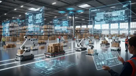
The Future of Semantic Spatial Intelligence
The trajectory of this technology points toward a horizon where “spatial foundation models” enable AI to possess a cognitive understanding of our world. We are moving away from simple navigation toward a phase where a machine can interpret the purpose of a room or the function of an object without human labeling. This breakthrough will likely revolutionize how we interact with autonomous infrastructure, as machines will finally be able to reason about their surroundings with human-like context.
As we look toward the next several years, the integration of augmented reality with these spatial models will create a more fluid interface for human workers. Imagine a technician receiving real-time, spatially anchored instructions that are aware of the specific tools and parts present in their immediate vicinity. This level of environmental reasoning will transform spatial intelligence from a niche technical tool into a pervasive utility that enhances human capability across every major industry.
Final Assessment of Spatial Intelligence Platforms
The evaluation of platforms like Scaniverse and VPS 2.0 demonstrated that the industry successfully bridged the gap between theoretical spatial modeling and practical, large-scale utility. These systems provided a robust framework for both the capture of complex environments and the precise localization required for modern robotics and industrial management. By prioritizing accessibility and high-fidelity 6DoF orientation, the technology overcame many of the limitations that previously hindered the adoption of digital twins in everyday operations.
The shift toward semantic reasoning and edge-computing optimization marked a significant milestone in the maturity of spatial computing. These advancements ensured that the technology remained relevant in a rapidly changing digital landscape, offering more than just maps, but true situational awareness. Ultimately, the development of these spatial intelligence platforms laid the groundwork for a future where the physical and digital worlds operate as a single, cohesive entity, fundamentally altering our relationship with the spaces we inhabit.